
This pit, also known as Higgins Clough Pit, was situated on the offside of the canal on the approach to Higgins Clough Swivel Bridge. It was on land owned by Thomas Legh of Lyme Hall and it is possible that the sinking of the shaft was contemporary with the opening of the upper level of the canal on the 31 Aug 1796, although there no evidence for this.
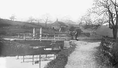
Higgins Clough Swivel Bridge, c.1930.
This bridge is a short distance to the south of the site of Hag Bank Colliery and it is seen here looking towards Marple.
This pit was originally worked by Messrs J & J Dodgson (John and James) and coal from it was used to fire the company's three Disley Lime Kilns. An important customer was Samuel Oldknow who bought coal from them to help fire his lime kilns at Marple. He used coal from it to supplement coal obtained from his three coal pits near Brick Bridge. By 1805, Hag Bank Colliery was being worked by the Trustees of Messrs J & J Dodgson, so presumably the brothers had died. In 1806 a newspaper advertisement was offering the pit and associated lime kilns for sale or letting.
The schedule accomanying the 1851 Tithe Map shows that by this time the occupier was James Clayton who was also working the pit. The Ordnance Survey map for 1872 shows it as an 'Old Shaft' but it was reopened by Sampson Maiden who worked it during 1875-76 after which it closed again. Sampson Maiden was also working a pit in Disley over the period 1872-88.
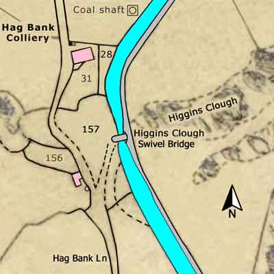
Hag Bank Colliery &
Higgins Clough Swivel Bridge
Upper Peak Forest Canal
Grid Ref: SJ 974 856
Tithe Map: 1851, Ref: EDT 137/2
Courtesy: Cheshire Archives & Local Studies
Tithe Schedule, 1851
Township: Disley
Parish: Stockport
Landowner: Thomas Legh (1792-1857) of Lyme Hall, Disley
| Plot | Plot Name | Occupier | Land Use |
|---|---|---|---|
| 28 | Coalpit & Waste | James Clayton | Waste |
| 31 | House, Building, Yard & Garden | James Clayton | Building & Garden |
| 156 | Cottage & Garden | Samuel Pott | Building & Garden |
| 157 | Waste at Higgins Clough | James Clayton | Waste |
Coal Bill
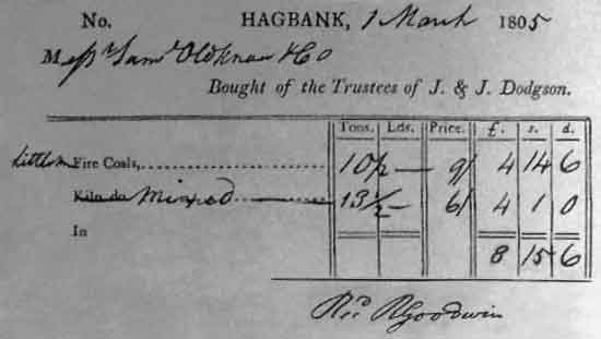
The above bill, dated 1 Mar 1805, is for 'Little Fire Coals' and 'Mixed' (Coals) bought by Samuel Oldknow & Company from the Trustees of J & J Dodgson.
10½ tons of Little Fire Coals at 9s 0d per ton  =  £4 14s 6d
13½ tons of Mixed (Coals) at 6s 0d per ton      =  £4  1s 0d
                                         Total  =  £8 15s 6d

The bill was signed for at Marple Lime Works by the Clerk, R Goodwin.
Coal Shaft
A short distance before Hag Bank Colliery is the site of a coal shaft that was associated with Hag Bank Colliery.
This shaft was not recorded on the Tithe Map but the occupier in 1851 was James Clayton and the landowner was Thomas Legh.
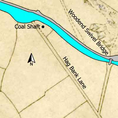
Coal shaft associated with
Hag Bank Colliery
Upper Peak Forest Canal
Grid Ref: SJ 975 856
Tithe Map: 1851, Ref: EDT 137/2
Courtesy: Cheshire Archives & Local Studies
