
It is likely that the Disley Lime Kilns on the Upper Peak Forest Canal were built by Messrs Wright and Brown. They were three in number and they were sited on the offside of the canal between Higgins Clough (Disley or Shaley Knowl) Swing Bridge and Dryhurst Bridge, being about 200 yards to the west of the latter bridge. They stood on land owned by Thomas Legh (1792-1857) of Lyme Hall, Disley, where the lie of the land was suitable for their construction, being higher at the back (for loading the kilns with limestone and coal) and lower at the front (for the removal of burnt lime and ash).
Their construction was possibly contemporary with the opening of the upper level of the canal on the 31 Aug 1796, to enable them to receive limestone from Bugsworth Basin, although there is no evidence for this. The earliest known reference to them was in an advertisement in the Manchester Mercury, dated 8 Mar 1802:
To Let. Lime Kilns at Disley, near coal pits now working under the direction of Messrs. Dodgson, apply at Hagbank Colliery, Nr. Disley.
This advertisement shows that coal used to fire the kilns came from Hagbank Colliery operated by Messrs Dodgson and that anyone interested in leasing the kilns should apply to Hagbank Colliery.
It seems that the kilns were eventually leased to the Peak Forest Canal Company on the 1 Jun 1802 for a period of three years. The lease included:
···· the Engine, Machinery, Ropes, Waggons, Railways, Buildings, Roads and Wharfs thereto belonging.
Farey, writing in 1817, describes the kilns as follows:
At Disley Wharf, ¼ mile NE of the Town, there is a short inclined-plane, on which a small Whimsey Steam-engine is used to draw up loaded Trams of Limestone and Coals, from the Boats on the Canal, to the tops of the Lime-kilns; whose bottoms or draw-holes are above the Canal, for the convenience of loading Boats and Carts with Lime.
During the lease of the kilns by the canal company coal was provided by Hagbank Colliery and when this lease expired they passed back to the owners of Hagbank Colliery.
Another reference to the kilns comes from the minute books of the Peak Forest Canal Company for 1803, which mentions lime being sold at Disley.
From two surviving coal bills for the sale of coal to Samuel Oldknow at Marple Lime Works, it is known that around this time that Hagbank Colliery was controlled by the Trustees of J & J Dodgson. These bills are dated, 1 and 19 Mar 1805, respectively.
Another reference to the kilns is in an advertisement in the Manchester Mercury, dated 4 Mar 1806:
Valuable Collieries and Farm to be let or sold by private contract ···· All those messuage, lands and hereditaments, situate in Disley called THE HAGBANK FARM And also, all those valuable Mines of Coal, lying under the same premises, together with the steam engine, machinery, and utensils, now used for getting the same. And also, all those three well constructed Lime Kilns, lately erected on the said premises ····
The advertisement then goes on to give particulars of the facilities available and concludes with the information that 'an active purchaser' can expect to make a clear profit of at least £1,000 per annum.
This advertisement shows that the vendor owned both the coal mines and lime kilns and implies that they were occupying the same site. This was not quite correct, as they were about 375-yards apart.
A plan dated 1844 shows that the kilns were then occupied by John Marsland and the Tithe Map and Schedule for the locality, drawn up in 1851, shows that the kilns were disused by this time.
The Tithe Act of 1836 enabled the government to commute tithes throughout the country, and this meant a change from tithes as a payment in kind to the clergy to one of a financial amount based on current crop prices. This Act resulted in the first systematic survey of most of the land in England and Wales, with much of this work being done between 1840 and 1850.
Tithe Schedule, 1851
Township: Disley
Parish: Stockport
Landowner: Thomas Legh of Lyme Hall, Disley
| Plot | Plot Name | Occupier | Land Use |
|---|---|---|---|
| 172 | Old Lime Kilns, Wharf, Cottage and Road | Thomas Parker | Buildings and Thoroughfare |
| 190 | Kiln Meadow | Samuel Howard | Pasture |
| 191 | Kiln Meadow | John Marsland | Meadow |
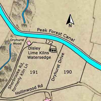
Disley Lime Kilns
Upper Peak Forest Canal
Grid Ref: SJ 978 850
Tithe Map: 1851, Ref: EDT 137/2
Courtesy: Cheshire Archives & Local Studies
Acknowledgement
O Bowyer for the advertisement about the letting or sale of Hagbank Farm.
O Bowyer, The Peak Forest Canal: Its Construction and Later Development (New Mills Local History Society, 1988).
