
Bugsworth Canal Basin, tramway, quarry and limekilns.
Scheduled Monument, List Entry Number: 1021384.
Introduction
The Black Brook rises on Barmoor Clough at an altitude of 1,200 feet, some 400 yards east-northeast of Bolt Edge Farm.
This point is close to Bennetston Hall (Coach House, Buxton, Derbyshire, SK17 8EY), which stands by the A623 trunk road and the Ebbing and Flowing Well, which is a Holy Well or Sacred Spring.
It then flows for about six miles to its confluence with the river Goyt, near Bridgemont.
Over that distance it falls by about 710 feet at an average gradient of 1 in 44.62 (1.28° or 2.24%).
The river first skirts around Bolt Edge and then turns to flow in a north-westerly direction through the hamlet of Blackbrook and, skirting around Chapel-en-le-Frith, it passes through Townend and then below the Peak Forest Tramway in a culvert adjoining the bottom of the Great Inclined Plane. After emerging from this culvert it turns in a westerly direction to pass under the Peak Forest Tramway again near Stodhart Tunnel and then on to Chapel Milton. At Chapel Milton, Hockham Brook joins the Black Brook and the former rises to the west of the 1,772-foot peak, known as the Lord's Seat, to flow through the hamlet of Wash. The Black Brook then flows on to Bridgeholme Green, Chinley, Whitehough and Buxworth, beyond which, on the approach to Bridgemont, it joins the river Goyt on its way to Stockport.
In the vicinity of Bugsworth Canal Basin, there are, and were, a number of noteworthy features. Referring to the above map:
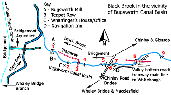
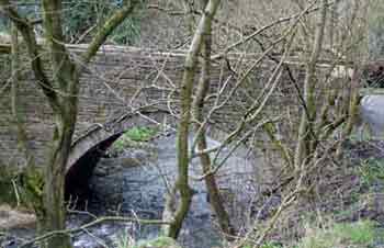
1, Access Bridges to Bugsworth Mill, one low level and one high level
The low-level bridge is of arched stone construction and its design is similar to the accommodation bridges built over
the Peak Forest Canal. This bridge pre-dates the building and opening of the Bugsworth New Road turnpike and its original purpose was to connect the wharf, lying to the west of Teapot Row,
to the mill and it would also provide a
river crossing for the residents of Teapot Row. Hereabouts the river banks are made up of solidified lime ash from Bugsworth lime kilns and this is still clearly visible.
Little is known about the high-level bridge, as there are no records or photographs of it. It had tall stone abutments on either side of the Black Brook and it is known that it accessed the mill on the first floor. It is likely that the bridge deck was of timber construction. Its purpose was to provide direct access between the wharf and the mill but its dates of erection and demolition are unknown.
2, Access Footbridge adjoining the Wharfinger's House/Canal Office
It is not known why this footbridge was built but it is likely that it was for the convenience of the wharfinger, his family and staff.
It was sited between the house and the adjoining stable. There are no records or photographs of it but it is likely that it was of timber construction with handrails,
similar in design to the two horse-transfer bridges at Bugsworth Basin.
It is not known when it was erected or demolished.
3, Tramway Access Bridge to the Lower Basin Wharf (New Drop)
This bridge was sited about 20 yards to the east of horse-transfer bridge 58. From the wharf, the tramway went due north to cross the
river and then it curved sharply to the west through an angle of about 90º. It then ran parallel with Bugsworth Mill head race as far as the access road from Bugsworth New Road turnpike but
the head race continued below the access road to the penstock of
the waterwheel that powered the mill.
The existence of this bridge and tramway is only known from a map and there are no photographs or other records of it. It is likely that the bridge was of timber construction but its dates of erection and demolition are unknown.
The purpose of this short isolated tramway is unknown but these reasons are possible,
Bugsworth Mill was rebuilt in 1851 and it was for the supply of building materials.
Prior to the building of Bugsworth New Road turnpike, it was for the conveyance of raw materials and finished goods to and from the mill. This would be an alternative and/or supplement to using the low-level bridge adjoining the mill.
For the disposal of lime ash from the Gnat Hole lime kilns. It is known that lime ash was dumped in large quantities on the narrow strip of land between the mill head race and the Black Brook.
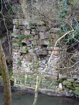
4, The Weir
The Black Brook was diverted to the north of the site of Bugsworth Basin and during construction of the channel opportunity was taken to build a weir to impound water to create a
head of water at Bugsworth Mill. From above the weir water flowed along a headrace, passing through a millpond (reservoir), to the waterwheel.
The inlet to the headrace incorporated a sluice that could be adjusted to control the supply of
water or be closed for maintenance purposes. At the waterwheel there was a penstock used to control the flow of water onto the wheel.
The weir is an overflow-type dam and its purpose was to raise the level of the river so that there was a difference in water level above and below the waterwheel (the head) to drive it and thus provide sufficient energy to power the mill. Once the water had passed over the waterwheel it entered the tailrace and flowed back into the river. The complete watercourse was known as a millrace, the headrace part being used to supply water to the waterwheel while the tailrace returned spent water from it back to the river.
5, Three Access Bridges to the New Road Lime Kilns
The purpose of these three bridges was to enable burnt lime from the New Road lime kilns to be barrowed over the Black Brook and
into the lime shed that spanned the head of the Middle Basin Arm. Here the lime could be loaded into waiting boats without risk of it getting wet when it was raining.
It is known that these bridges were of very simple construction consisting of wooden planks laid over the river.
6, Brookside Bridge
This is the first of the two arched stone bridges over the diverted Black Brook. It is sited to the northwest of the Navigation Inn and its purpose was to maintain a
road communication (formerly a packhorse road) between Macclesfield/Whaley Bridge and Chinley/Glossop via Chinley Road Bridge over the Peak Forest Canal.
7, Tramway Bridge
At the same time that the Black Brook was diverted, the road along the valley bottom from Whitehough to Whaley Bridge (over Silk Hill) had to be re-aligned as well and
the second of the two arched stone bridges was erected over the new channel of the river to the north of the Navigation Inn and this joined Brookside to maintain a connection with the road between Whaley Bridge and Chinley.
Subsequently, the valley bottom road became the main line of the Peak Forest Tramway and this bridge was used to carry the earlier of two tramway branches to the head the New Road Lime Kilns.
8, Twin Tramway Bridges
Two adjoining skew bridges that carried the elevated tramway branch to the New Road lime kilns, firstly over a medieval packhorse road and
then over the Black Brook. The stone arches of both bridges are formed of spiral courses and this enabled the crossings to be made at a skew angle rather than at a right angle.
These bridges date from the late 1860s.
9, Brook Bridge
This footbridge is of timber construction with handrails and it is sited close to the point where the elevated tramway branch to the New Road lime kilns left the
main line of the Peak Forest Tramway.
Bugsworth Mill low-level access bridge, Mar 2005.
This view of the bridge is from the left-bank of the Black Brook looking up stream.
Bugsworth Mill high-level access bridge, Mar 2005.
Both bridge abutments are still extant and this one is on the left bank of the Black Brook.
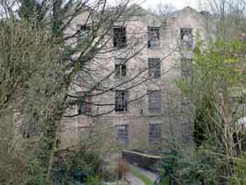
Bugsworth Mill with the low-level access bridge in the foreground, Mar 2005.
On the night of the 28/29 Aug 2005 the mill was destroyed by fire.
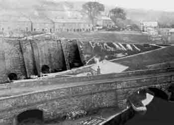
New Road lime kilns and lime shed, early 20th century.
One of the three lime kiln access bridges over the Black Brook can just seen in this view. It is located (as a thin horizontal white line) to the left of the lime shed.
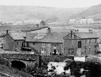
The rear of the Navigation Inn with Brookside Bridge in the left foreground, early 20th century.
This view is from the right bank of the Black Brook. Note the solidified lime ash forming the river bank to the right of the bridge.
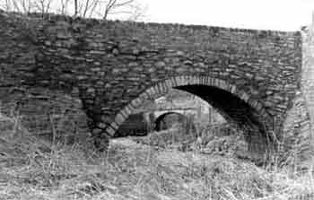
Tramway Bridge, Apr 1980.
The bridge is seen from the left bank of the Black Brook looking downstream. It was built to maintain a connection between the valley bottom road from Whitehough and the road between Whaley Bridge and Chinley.
Subsequently, the valley bottom road became the main line of the Peak Forest Tramway and this bridge was used to carry the earlier of two tramway branches to the head of the New Road lime kilns.
The bridge in the background is Brookside Bridge.
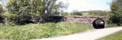
Two adjoining skew bridges that carried the elevated tramway branch, 2004.
The tramway bridge over the Black Brook is on the left in this view.
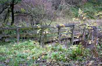
Brook Bridge, Nov 2004.
The footbridge is viewed from the left bank of the Black Brook.
Railway Diversion at Bugsworth
In the wet autumn of 1866, the recently opened Midland Railway line through Bugsworth (then connecting Derby and Manchester) began to slip down the valley side towards the Black Brook.
Altogether, some 16 acres of land were caught up in the slip. The line had been built on glacial sands and boulder clay overlying shale and sandstone.
The most vulnerable structure affected was a five-arched viaduct where cracks were observed, followed by movement. The viaduct was declared to be unsafe and was replaced by a temporary trestle bridge
constructed alongside the viaduct on its northern side. This contained some 50,000 feet of pitch pine from the Baltic. This structure stood from 1866 until 1885.
The line was permanently diverted to the rear (north side) of Bugsworth Station, which then made it back-to-front. The diversion required an embankment to be constructed through Brierley Green
that required 32,000 tons of stone, clay and earth as well as 25,000 tons of ashes. The line was re-opened in Feb 1867.
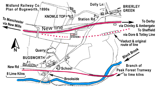
Plan based on one made by the Midland Railway Co in the 1890s.
It shows how their railway line through Bugsworth was diverted to the rear (north side) of Bugsworth Station following a land slip in the autumn of 1866 that caused a five-arched aqueduct to become unsafe and require demolition. This is shown to the east of Bugsworth Station, the original route of the line being shown by a dotted line.
Bugsworth Station was closed permanently by British Rail on the 15 Sep 1958.
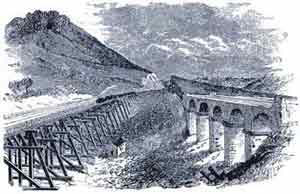
An engraving with the original viaduct on the right and a temporary trestle bridge on the left.
Thirty-five years later, in 1902, the number of tracks was increased from two to four to cater for increased traffic. Consideration was given to the possibility of either building a second tunnel at Bugsworth or demolishing the original tunnel to create a wide cutting but eventually the latter option was chosen. This resulted in Bugsworth Tunnel, to the west of Bugsworth Station, being demolished and replaced by a wide cutting but the northern side wall of the tunnel was retained to act as a retaining wall. This work also entailed the construction of a massive blue-brick retaining wall, comprised of blind arches, where the railway line and New Road, between Bridgemont and Bugsworth, are juxtaposed.
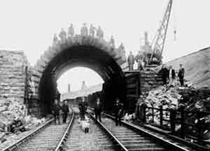
The remaining north portal of Bugsworth Tunnel prior to its demolition on the 10 Aug 1902.
