
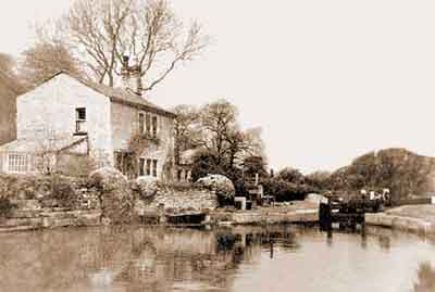
Lock 6 with the lock house (Glen Cottage) on the left, early 20th century.
It is understood that this lock house was built in 1835 and it was demolished in 1962. The 1850 Tithe Schedule describes it as a 'Building and Garden', but two buildings are shown on the Tithe Map. At this time, the owner of the land on which the house stood (Plot 176) was the Peak Forest Canal Company while the occupier was the Manchester, Sheffield and Lincolnshire Railway Company.
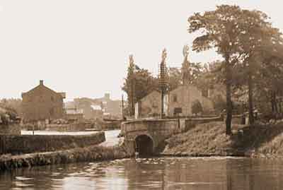
Brabyns Change Bridge with lock 9 beyond the bridge, 1906.
A lock house stands to the right of the lock and the building beyond it is a stable block. Samuel Oldknow's warehouse is on the left and boats could load and unload here under cover. The entrance lodge to Brabyns Park is just visible on the left. It is understood that the lock house was built in 1834.
The 1850 Tithe Schedule describes the lock house as a 'House and Yard'. At this time, the owner of the land on which the house stood (Plot 247) was the Peak Forest Canal Company while the occupier was the Manchester, Sheffield and Lincolnshire Railway Company.
Brabyns Change Bridge stands at the top of Brabyns Brow, where the name changes to Station Road, and the name is derived from the country estate of Dr Henry Brabbins, which adjoins the canal and is now known as Brabyns Park. The estate was founded in 1745 and Dr Brabbins was a surgeon in Stockport. Parish records show that a Henry Brabbins was buried in the ecclesiastical parish of Prestbury, Cheshire, on the 18 August 1750. Prestbury parish was large rural parish at this time.
The 1850 Tithe Schedule shows that by this time Brabbins Hall and surrounding estate was owned and occupied by John Wright.
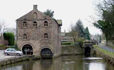
Samuel Oldknow’s Warehouse looking south with lock 10 to the right, Feb 2006.
This three-storey stone warehouse with an attic was built in the early 19th century and it stands on the offside of the canal on St Martin’s Road between locks 9 and 10.
The warehouse is seven bays long by three bays wide with a graduated stone-slate roof and a chimney at each end. The central bay on each side has a loading bay with jib, for loading and unloading, and a canopy above. The northern gable end has a shipping hole, where boats were loaded and unloaded under cover, and an adjacent entrance for road traffic. There is a blind central window at first floor level and a blind window at attic level. The southern gable end has a central door on the first floor and a blind window at attic level.
The entrances have semi-circular heads with a single ring of stone voussoirs. The window openings have semi-circular heads with a single ring of stone voussoirs and stone sills.
Samuel Oldknow’s Warehouse is Grade II listed, List Entry No. 1242465.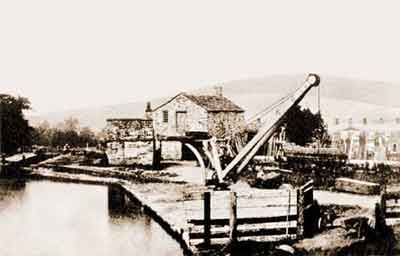
Lock 12 by Black Wharf with Smithy Cottage in the centre background, c.1852, Photo: Joseph Sidebotham.
This is the earliest known photograph of the Peak Forest Canal and it first appeared in The Strines Journal; A Monthly Magazine of Literature, Science and Art. The 1850 Tithe Schedule describes the area as 'Buildings and Wharf'.
It is understood that Smithy Cottage was built in 1834. The small building in the foreground is a blacksmith's shop and the terraced houses in the background on the right are on Brick Row (Long Row).
The owner of the land on which Smithy Cottage stood (Plot 238) was Peter Arkwright, grandson of Sir Richard Arkwright, while the occupier was Mary Ann Bowden. There has been a long-standing conviction that Smithy Cottage was used as a lock house but the information given on the Tithe Schedule suggests that this may not have been the case in 1850. Whether it subsequently became a lock house is unknown. The adjoining blacksmith's shop (Plot 237) was owned by the Peak Forest Canal Company while the occupier was the Manchester, Sheffield and Lincolnshire Railway Company. It is estimated that this building was demolished in the early 1960s.
On the 16 Sep 1967, a group of over 50 volunteers from the Peak Forest Canal Society and the London and Home Counties Branch of the Inland Waterways Association gathered at lock 12 to clear the chamber. Items recovered from the chamber during clearance included: bellows (bearing the Coat of Arms of the Sheffield manufacturer), an anvil, an iron tank and a range of blacksmith's tools. Additionally, there were items of lock-operating gear including several racks and other paddle gear parts. This important group of artefacts associated with the Peak Forest Canal was immediately removed from the site and dispersed but their whereabouts are now unknown.
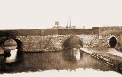
Posset Bridge viewed from Black Wharf pound with lock 13 beyond the central bridge hole, c.1920. This view shows the bridge before the road was widened.
Lock 13 is beyond of the central bridge hole and the bridge hole on the left accessed the Lower Private Branch to Marple lime kilns. The small bridge hole on the right is a horse-transfer tunnel used by horses hauling boats.
The first locks to be completed in the Marple flight were locks 13, 14, 15 and 16 and it is possible that they opened on the 13 October 1804. It is said that Samuel Oldknow's boat, Perseverance, was the first to lock down. Oldknow offered the workmen posset (a spiced drink made of hot sweetened milk curdled with ale or wine) to complete the locks on time and consequently the bridge became known as Posset Bridge.
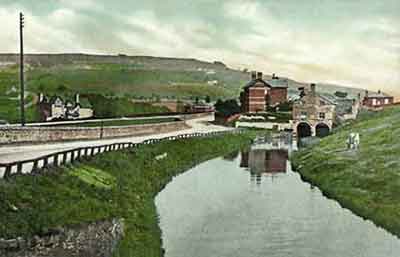
The Lower Private Branch to Marple lime kilns with Strines Road on the left, early 20th century.
This branch left the main line of the Peak Forest Canal at Posset Bridge behind the viewpoint. The kilns were supplied with limestone and coal brought along two short arms of the Upper Private Branch located near Top Lock (Lock 16). It entered the lime shed spanning the head of the branch, where two boats at a time could be be loaded undercover. Boats were loaded undercover because lime had to be kept dry until it was required for use.
