
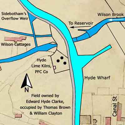
The tithe map of 1841 shows three lime kilns, standing on land owned and occupied by the Peak Forest Canal Company, situated to the north of Hyde Lane Change Bridge. The surrounding field was owned by Edward Hyde Clarke and occupied by Messrs Thomas Brown and William Clayton. Despite the kilns being occupied by the Peak Forest Canal Company, the practicality is that they were operated by Messrs Brown and Clayton.
Messrs Nathaniel Wright and Thomas Brown had built two kilns on this site by 1800 and their construction was contemporary with the opening of the lower level of the canal. As the tithe map shows, there were three kilns by 1841 and Thomas Brown’s business partner had changed from Nathaniel Wright to William Clayton. Thomas Brown was the Resident Engineer for the construction of the Peak Forest Canal. These kilns are not shown on the Ordnance Survey map of 1872 so they must have become disused prior to this date.
The layout of the kilns is unusual because in plan view they formed a triangle rather than the more customary linear arrangement. The top of the kiln pots was probably at canal level for the convenience of charging them with limestone and coal. Limestone would have been transported by boat from Bugsworth Basin at the terminus of the Peak Forest Canal and coal used to fire the kilns probably came from Hyde Lane Pit, which was about 200 yards to the south of the kilns. This pit was occupied by Messrs Brown and Clayton.
The kiln draw tunnels, used for the removal of burnt lime and ash, were below canal level but their location cannot be identified from the map. It can only be assumed that the entrances were somewhere in the south and/or west facing walls. As burnt lime was removed from below canal level it would seem that it was transported away by horse and cart rather than by boat. This might explain the absence of a lime shed by the canal where boats could be loaded under cover to keep the lime dry.
Hyde Lime Kilns
Lower Peak Forest Canal
Grid Ref: SJ 943 952
Tithe Map: 1841, Ref: EDT 217/2
Courtesy: Cheshire Archives & Local Studies