
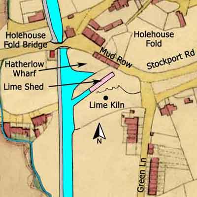
Hatherlow Wharf is situated directly to the south of Holehouse Fold Bridge, Romiley, and in 1849 its purpose was to receive limestone and coal for consumption in the lime kiln standing on the wharf. The resultant burnt lime (quicklime) would then be taken away by boat or by horse and cart for use elsewhere. The map shows only one kiln to be operational at this time, as only one pot has been depicted. Yet, the front wall of the kiln clearly shows that initially there were three kilns here of which only the most westerly is still in use.
The head of the short canal arm adjoining the front of the kiln was spanned by a lime shed the purpose of which was to keep burnt lime dry while it was being loaded into a boat. It was essential to keep lime dry otherwise it would 'fall' and be spoiled.
The Schedule accompanying the map states that the wharf was both owned and occupied by George Andrew and that it consisted of a 'Lime Kiln and Weigh House'. The latter was associated with the lime shed because each loaded boat had to be gauged to determine the weight of burnt lime it was carrying before it could proceed. Once this was done a permit was be issued to the boatman and the boat could then leave for its destination.
Hatherlow Wharf
Lower Peak Forest Canal
Grid Ref: SJ 936 906
Tithe Map: 1849, Ref: EDT 341/2
Courtesy: Cheshire Archives & Local Studies