Tame Viaduct 'Sixteen Arches'
This viaduct stands on the Sheffield & Midland Joint Railway that was a venture between the Manchester, Sheffield & Lincolnshire Railway Company and the Midland Railway Company.
Known as the Sheffield & Midland Railways Committee, this committee fulfilled the need of the Midland Railway Company to build a line into Manchester from London via Ambergate and Millers Dale in Derbyshire.
In 1867 this line was joined to the Manchester, Sheffield & Lincolnshire Railway at Hyde Junction, via Romiley, Woodley and Hyde
but by 1875 a more direct line was being built to eliminate the diversion via Hyde Junction. This line was being built through Strines, Marple, Bredbury, Brinnington, Reddish North, Ryder Brow, and Belle Vue.
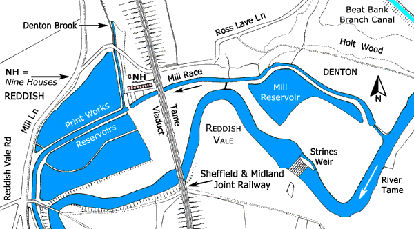
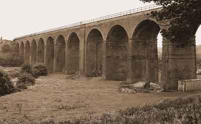
The line had to cross Reddish Vale, through which the river Tame meanders to join the river Goyt in Stockport and become the river Mersey. To accomplish this, the line was carried on a viaduct comprised of 16 semi-circular brick arches mounted on brick piers, the central pier being larger in section. The imposts supporting the arches were constructed of stone. Officially known as the Tame Viaduct, it is better known by its colloquial name of 'Sixteen Arches'.
Tame Viaduct is part in Denton, Tameside, and part in Reddish, Stockport. The whole viaduct was first listed Grade II, List Entry No. 1067190. Later, the part of the viaduct in Denton became listed Grade II, List Entry No. 1389626.
Reddish Vale, 1904.
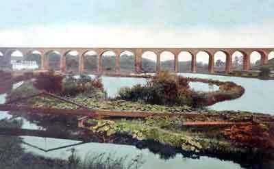
Tame Viaduct looking north east, early 20th century.
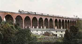
The Print Works Reservoirs are in the foreground and Nine Houses are in the background on the left.
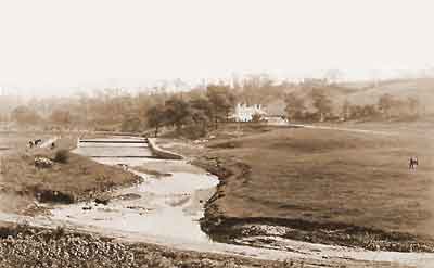
Strines Weir looking south east, early 20th century.
Strines Cottages are in the background centre right. They were a yeoman’s farm before being converted into three cottages and later they were converted into four cottages.
Strines Cottages were demolished in c.1940 when the Civil Defence built a bomb decoy on the Denton side of the river and the weir was destroyed by a flood in the 1960s.
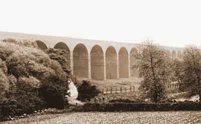
The east elevation of Tame Viaduct viewed from Mill Ln, Reddish, post c.1914.
The lane passing below the viaduct on the left is Ross Lave Ln (formerly Consterdine Ln) leading to Denton. Ross Lave Ln joins Reddish Ln off the picture to the right. In the foreground on the right part of the print works reservoirs is just visible.
By the time this photo was taken Nine Houses alongside the viaduct had been demolished.
The west elevation of Tame Viaduct viewed from Ross Lave Ln, Denton, Aug 1986.
A water-powered corn mill once stood on the site of the two calico print works reservoirs but following a downturn in corn milling it was converted into a school known as 'the Ark'. This was then demolished to enable two reservoirs for the print works to be constructed.
At one time there were three reservoirs in Reddish Vale. The two print works reservoirs were situated to the west of Tame Viaduct while an earlier reservoir was to the east. This was connected with the corn mill and it is no longer extant.
It is understood that the calico print works was founded in 1780 by a Mr Francis but his business failed and for over half a century it was owned by several proprietors. By 1825 the business was operated by a John Fletcher and by 1840 it was operated by Becker Brothers who had four printing machines and 118 block printing tables. In 1862 the print works was acquired by Bradshaw, Hammond & Co Ltd of Levenshulme, Manchester and in 1899 it became part of the Calico Printers Association.
The print works remained open until 1952 and subsequently the buildings were converted into industrial units. It is understood that in 1978 a brewery moved into the premises only to move out again in 1978. Eventually the buildings were demolished and the site was re-wilded to become a butterfly conservation field in the Reddish Vale Country Park.
A surviving building associated with the print works is Tame House. Now fully restored, this house was situated by the entrance to the print works and it was built in c.1928 for the works manager, a Mr Wilson. Nowadays it is adjacent to the Visitor Centre for Reddish Vale Country Park by the junction of Reddish Vale Rd and Mill Ln.
The Reddish Vale print works was one of several calico print works established to the south of Manchester and during the 19th century it expanded to become an important employer.
The row of terraced houses standing in the shadow of the viaduct on its western elevation was long considered to have been provided for viaduct construction workers but the 1871 census shows that it was already extant at a time prior to its construction and five of the occupants were workers at the calico print works. At this time there were nine houses in the row and this gave it its colloquial name of 'Nine Houses'. By the time of the 1901 census there were only eight houses in the row and maps and photographs of the day verify this. The above map suggests that house Nos. 6 and 7 were knocked together to create one dwelling and it may be no coincidence that No. 7 was uninhabited at the time of the 1871 census.
There is a legend that on no account must anyone visiting Reddish Vale count the number of arches in the viaduct. It is said that a witch placed a curse on the viaduct, so that anyone counting the number of arches would have some bad luck. It is likely that this legend arose because the residents of Nine Houses objected to the viaduct being built alongside them.
Nine Houses & Strines Cottages
During the 19th and early 20th centuries, Reddish Vale was popular with day-trippers from surrounding townships and it is said that the occupants of Nine Houses and Strines Cottages
did a roaring trade selling pots of tea and jugs of water to these trippers. Nine Houses survived until the Great War (1914/18) when the row was demolished in c.1914. Strines Cottages were demolished in c.1940
when the Civil Defence built a bomb decoy on the Denton side of the river.
Left: The 1871 census records Nine Houses as Nos. 1 to 9 Reddish Vale, Denton.
Right: The 1901 census records Nine Houses as 1 to 8 Reddish Vale, Denton. Nos. 6 and 7 had been knocked together to make one dwelling.
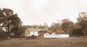
Left: Nine Houses, 1905, and right: Strines Cottages, early 20th century.
Arden Hall
Arden Hall is situated on Far Cromwell Rd, Castle Hill, Bredbury.
A stone on a spout above the entrance to the great hall is inscribed, 1597, and another stone inscribed, R A 1597, is in the right-hand gable, thus 1597 is taken to be the year in which the present hall was built.
It stands at an imposing position above the south side of the valley of the river Tame. It overlooks Reddish Vale at site location, 53.43667, -2.12361.
For over two centuries it was owned by the Ardern(e) family who owned other land and property in Cheshire.
This family was a branch of the Arden family of Warwickshire. William Shakespeare’s mother, Mary Arden (c.1537-1608) was a member of the Arden family that can trace its lineage back to Anglo-Saxon times.
The surname takes its name from the Forest of Arden in north Warwickshire.
The hall is listed Grade II, List Entry No. 1259976.
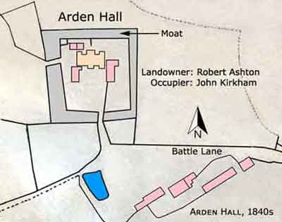
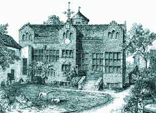
Arden Hall was built of dressed stone with ashlar dressings and a stone slate roof and it was surrounded by a moat. It was three-storeys high with a central watchtower at the rear overlooking Reddish Vale. On the front elevation there were originally three gables, with the central and right-hand gables projecting from the face of the hall while the left-hand gable was flush but only left-hand and central gables remain. The entrance to the great hall was in the central gable on the right-hand side and it was approached from the courtyard by a flight of steps. Passing through the doorway a large door on the right opened into the great hall. Opposite this there was a wide staircase that accessed the watchtower and upper floors of the hall. At one end of the great hall there was a raised platform where the high table was situated. Lighting was provided by stone mullion windows, these being structural elements that helped to support the weight of the walls around them. The top-floor windows of the gables had three-light windows with cusped heads. The hall is now in a ruinous condition, as it has been for some considerable time.
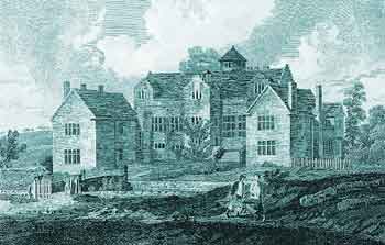
Arden Hall late 18th century.
Arden Hall late 18th century.
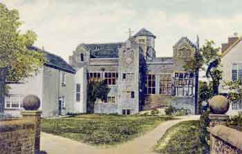
Arden Hall, early 20th century.
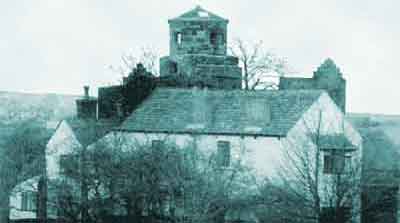
Arden Hall looking north east, early 20th century.
There is a belief that Oliver Cromwell stayed at the hall and that there was a skirmish nearby between Cavaliers and Roundheads but there is no corroborative evidence for this. Access to the hall via Castle Hill from Ashton Rd, Bredbury, is now called Far Cromwell Rd but this was formerly called Battle Ln. The occupier of the hall at the time of the Civil War (1642-49) was Ralph Ardern(e) who supported the Parliamentary cause and it is understood that he saw action in several engagements.
The Ardern(e) family disposed of their estate at Bredbury in 1825 and a sale in the same year stated that, ‘the ancient mansion house of Arden Hall has been in part converted into a commodious farm house, with every requisite convenience, and that it had already been let as such’.
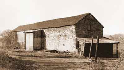
The barn is rectangular in plan with opposed cart entries and a stone slate roof. There is a hayloft as well as later additions. The datestone is inscribed, ‘AAA 1716’.
