Crown Point is a crossroads in Denton where four main roads separate the township into four parts. The first turnpike to be constructed through Denton was between Stockport and Ashton-under-Lyne and this dates from 1765. This resulted in two toll-bars (toll-gates) being erected at Crown Point, one across Ashton Rd (formerly Long Ln) and one across Manchester Rd. These were known as the 'Crown Point Bars'. The turnpike between Manchester and Stockport via Hyde came 53 years later in 1818 and it superseded Windmill Ln on the Manchester side and Broom Ln on the Hyde side. Part of Broom Ln survived in Haughton as Old Broom Ln. As a result of this, a third toll-bar was erected at Crown Point across Hyde Rd.
The toll house for the older Stockport - Ashton turnpike stood on the corner of Manchester Rd and Ashton Rd with one bar across Ashton Rd between the toll house and Crown Point Buildings and the other across Manchester Rd between the toll house and King's Head Inn. A second toll house was erected for the later Manchester - Hyde turnpike and this was constructed on Hyde Rd on the corner of Wild St behind the Old Red Lion. Thus the toll-bar across Hyde Rd was set back a short distance from Crown Point. Toll-bars on the Manchester - Stockport turnpike were abolished on Saturday, 1 November 1879, amidst much celebration, and it is likely that those on the Stockport - Ashton turnpike were abolished around the same time.
The Manchester & Salford Trade Directory for 1832 records that the toll collectors at Crown Point at this time were James Sykes and John Taylor.
Origin of the name Crown Point
It is understood that Crown Point was named after Fort Crown Point in the State of New York,
U.S.A. Crown Point (French: Pointe à la Chevelure) is situated at the end of a peninsular on the western shore of Lake Champlain towards its southern end and to the north of Ticonderoga.
The French built a fort on the site in 1734, named Fort St Frédéric, and British forces attacked this twice during the French and Indian War (1754/63) but the French destroyed it themselves in the summer of 1759 when they saw an overwhelming British force approaching. Commencing in the winter of 1759/60, the British then built a much larger fort immediately to the SW of Fort St Frédéric, which they named Fort Crown Point. In the course of time, Fort Crown Point was mostly used as a staging post rather than as a military position.
At the commencement of the American Revolution in 1775 the fort was garrisoned by a tiny force of nine soldiers and on the 12 May 1775 it was captured by 100 men of the Green Mountain Boys American Militia, commanded by Captain Seth Warner. This event came to be known as the Battle of Crown Point. It was then abandoned to the British in 1777 and it was permanently abandoned in 1780.
The ruins of Fort Crown Point are now a U.S. National Landmark known as the Crown Point State Historic Site.
 |
 |
Crown Point/Manchester Rd, early 20th century. View looking at the entrance to Manchester Rd from outside the Old Red Lion. Ashton Rd (formerly Long Ln) is on the right and Stockport Rd is off the picture to the left. The corner of the King's Head is just visible on the left. The toll house for the Stockport - Ashton turnpike formerly stood on the site of the corner shop and toll-bars were erected across Manchester and Ashton Roads. By 1914 the corner shop on Ashton Rd was occupied by John Hulme, a tripe dealer, and later he moved round the corner onto Manchester Rd. John Hulme was born at Stockport on the 12 Dec 1851 to Joshua Hulme and Mary Kemp who were married at St Mary’s Church, Cheadle, in 1849. He married Margaret Ann Bent at Ashton-under-Lyne on the 14 Dec 1874. She was born at Droylsden in 1856. In 1911 he was resident with his wife and family on Ashton Rd, Denton, employed on his own account as a tripe dealer. John died on the 27 Jan 1939, aged 88 years, and Margaret Ann died on the 15 Dec 1938, aged 82 years. |
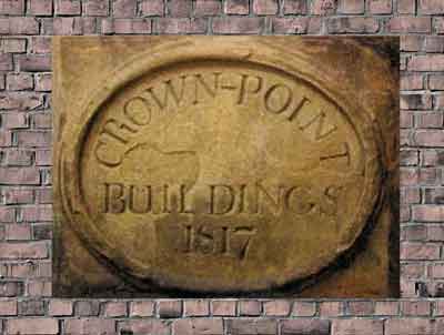
Crown Point/Hyde Rd, early 1920s. View looking along Hyde Rd with Ashton Rd to the left and Stockport Rd to the right. The newsagent's corner shop on the left is part of Crown Point Buildings that were built in 1817 and the stone tablet between the shop window and the window above is inscribed 'CROWN-POINT BUILDINGS 1817'. The left-hand section of the building subsequently became the Exchange Inn, which received a licence as a beer retailer in 1840. The inn closed on the 4 Jun 1919 following which it was converted into a branch of Williams Deacon's Bank. Later, Crown Point Buildings, including the corner shop, were demolished and a new bank was built on the site. The bank became Williams & Glyn's Bank and then the Royal Bank of Scotland. The Old Red Lion is on the right and the entrance to Wild St, where the second toll house was built on the corner, is behind the Old Red Lion. When this picture was taken there was a tramway connection between Manchester and Hyde and between Manchester and Ashton. |
 |
 |
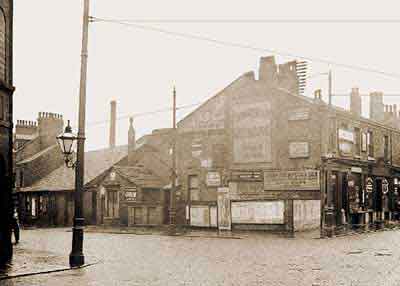
Crown Point/Ashton Road, c.1922. The former Exchange Inn after conversion into a bank by Williams Deacon's Bank Ltd. The Exchange Inn closed on the 4 Jun 1919 and the building was demolished in 1926 for road widening. |
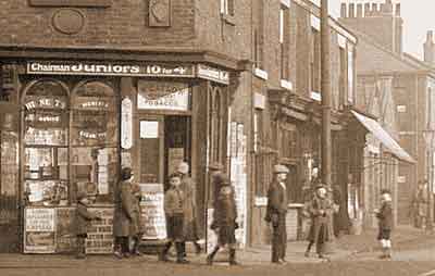
Crown Point/Hyde Rd, early 1920s. Detail of the newsagent’s corner shop. By 1914 it was occupied by the sisters Mary Elizabeth and Emma Marsden who were the daughters of Jacob Marsden (a cattle medicine agent) and Nancy Hadfield who were married at All Hallows Church, Almondsbury, Huddersfield, on the 7 Aug 1864. Mary Elizabeth was born at Lees, Ashton-under-Lyne, in 1868 and Emma was born Delph, Saddleworth, in 1871. |
 |
 |
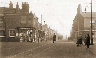
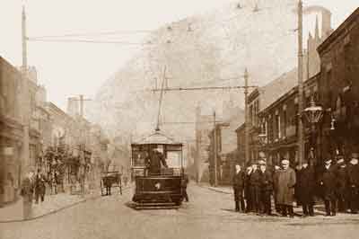
Crown Point/Ashton Rd, early 20th century. View looking along Ashton Rd with Manchester Rd to the left and Hyde Rd to the right. It shows the original tramway layout between Ashton and Hyde and the tram is about to turn into Hyde Rd. The street clock to the left of the tram marks the shop occupied by John Hallworth, a jeweller and watchmaker. John was born at Hindley, Leigh, Lancashire, in 1858 to Henry Hallsworth and Nancy Barrow (aka Burrows) who were married at St Thomas’s Church, Up Holland, Lancashire, in 1855. He married Elizabeth Smith at St Augustine’s Church, Salford, in 1879. The couple had three children, Ann (b. at Swinton, 1881), Henry (b. at Denton, 1883) and Clara (b. at Denton, 1885). The shops on the left were demolished and replaced by a new block of shops in 1916 and later Crown Point Buildings on the right were demolished and replaced by a Williams & Glyn's Bank. |
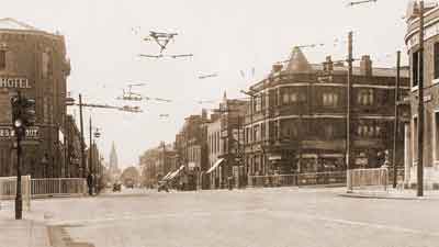
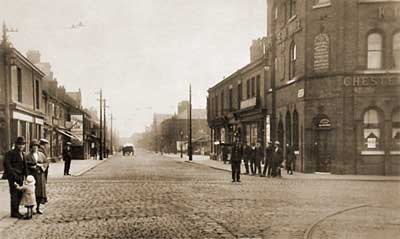
Crown Point/Stockport Rd, early 1920s. View looking along Stockport Rd with Hyde Rd to the left and Manchester Rd to the right. The King's Head Hotel on the right replaced the earlier King's Head Inn. Further along the road on the right, the opening between the buildings locates Market Place and in the distance the tall building is Hope Congregational Chapel and beyond is the police station. The Old Red Lion is on the left and further along the tall building is the Gardeners Arms (now the Queen Vic). Part of Stockport Rd was once called South St. This picture shows that by this time there was a tramway connection between Manchester and Hyde and in the foreground on the right the tramway connection between Manchester and Ashton can just be seen. |
 |
 |
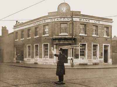
Crown Point, 1930s. View looking at Williams Deacon's Bank built on the site of Crown Point Buildings. Hyde Rd (right) and Ashton Rd (left). The office of the Federation of Hatmasters was on the upper floor this building. On the 1 May 2018 the RBS announced that this bank branch was to close. |
The date tablet from Crown Point Buildings. |
