
Phantom Lock
An examination of the official Western Canal Distance Tables published by the Manchester, Sheffield and Lincolnshire Railway Company (MS&LR) in September 1888 shows that the
Hollinwood Branch Canal had seven locks. The top lock on the main line of the Ashton Canal was numbered 18, so these seven locks were numbered sequentially, 19, 20, 21, 22, 23 24 and 25.
Similarly, Bradshaw's Canals and Navigable Waterways of England and Wales also listed seven locks but in this publication they were numbered 1 to 7. The table below compares the locations of these locks from a
datum at Fairfield Junction on the Ashton Canal.
| Actual Lock No. | MS&LR and (Bradshaw) Lock No. | MS&LR Location from Datum | Bradshaw Location from Datum |
|---|---|---|---|
| Miles Yards | Miles Yards | ||
| 19 | 19 (1) | 2 880 | 2 880 |
| 20 | 20 (2) | 2 968 | Not given |
| 21 | 21 (3) | 2 990 | Not given |
| 22 | 22 (4) | 2 1,078 | 2 1,100 |
| 23 | 23 (5) | 4 440 | 4 440 |
| 24 | 24 (6) | 4 638 | 4 660 |
| 25 | — | Phantom Lock | Phantom Lock |
| 26 | 25 (7) | 4 1,012 | 4 1,000 |
The reason for the discrepancies in distances is that Bradshaw's were rounded to the nearest furlong (220 yards) whereas the MS&LR's were rounded to the nearest chain (22 yards). It is likely that the compilers of Bradshaw's Guide obtained their details from the canal owners, as they would be physically unable to inspect every canal in the country, and in this instance this was from the Great Central Railway Company, the later name of the MS&LR. For this reason, Bradshaw's Guide showed the Hollinwood Branch Canal as having seven locks instead of eight, as did Hadfield and Biddle's book, Canals of North West England, Volume 2.
The chambers of the first four locks at Waterhouses are still extant so they can be counted and there are four of them. The mystery surrounding Phantom Lock concerns the locks between Bradley Bent Basin and Hardman Fold Basin. Were there three locks or four? All trace of these locks has long since been destroyed but there is ample evidence to show that there were, indeed, four in spite of the fact that official records of the MS&LR list only three. Where was Phantom Lock located and why was it 'air brushed' out of official records? The first question can be answered but the second one cannot.
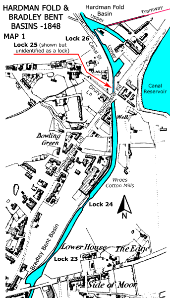
Left: Map 1 shows the section of the Hollinwood Branch Canal in question, as it was 1848. Lock 23, that lifted the canal out of Bradley Bent Basin, was identified as a lock but not numbered. Lock 24, adjoining Wroes Cotton Mills, was also marked as a lock but not numbered. Lock 25 (Phantom Lock) was close to the junction of Drury Lane and Canal Street with the turnpike (Manchester Road) and it was shown but, owing to a lack of space, it was not identified as a lock. Lock 26, that lifted the canal into the Upper Hardman Fold Basin, was identified as a lock but not numbered.
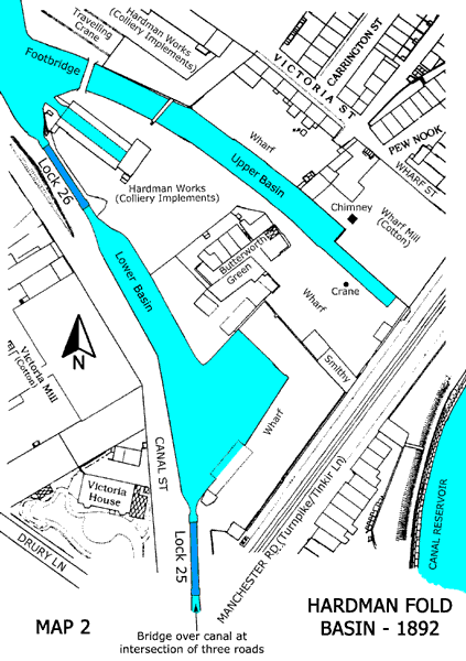
Right: Map 2 shows Hardman Fold Basin as it was in 1892 and this indicates Lock 25 (Phantom Lock) and Lock 26.
Regrettably, confirmation of the existence of Phantom Lock (Lock 25) does not explain why it was 'air brushed' away but it is difficult to believe that the MS&LR surveyors simply walked by without noticing that it was there. Could it be that the canal here was a sensitive issue with the MS&LR and that they did not wish to draw too much attention to it? Was the situation such that it was expedient to 'air brush' lock 25 out of existence for legal reasons that are now unknown? It is now too distant in time for the truth to be revealed but it could be connected with events discussed in the second part of this article. But, before then, the canal bridge adjoining this lock will be reviewed in some detail.
With reference to Map 1, the bridge over the canal by Lock 25 was quite a remarkable feature, now lost forever. From the beginning, the canal intersected the turnpike at an angle other than a right angle and it can be seen that the turnpike was carried over the canal on a skew bridge. At the time that the first bridge was built in the 1790s, the design of this type of bridge was still in its infancy. The crossing angle in this instance was about 52° from a right angle, which must be considered as a high skew angle. This presented an unknown engineer (possibly Benjamin Outram, Thomas Brown or even James Meadows Senior) with the challenge of having the arch, when viewed from above, distorted into the shape of a parallelogram, rather than the usual rectangle formed when crossing at a right angle. The consequence of this was to both flatten and twist the arch and the solution to this was to lay the stones forming the arch at an angle to the abutments (the piers on which the arch rests) and the effect of this was that it gave a spiral appearance to the masonry courses forming the arch. This technique provided extra strength in the arch that compensated for the angled alignment of the abutments. To compound matters still further, Drury Lane came in from the north west to join the turnpike at a right angle at the point where the bridge was built over the canal. Canal Street was built alongside the western side of the canal but in 1848 it appears that there may have been no connection between it and the turnpike.
This bridge did good service until the 1870s when a decision was made to upgrade the turnpike by widening it and, as a consequence, the first bridge was demolished, its replacement being built by June 1879. This bridge, supported by iron girders, was possibly more remarkable than its predecessor. There were shops on three corners of the parallelogram and on the fourth corner (on the north east) there was a gate that accessed a ramp down to a wharf at Lower Hardman Fold Basin where there was an office, long occupied by Joel Carrington (one of the Derbyshire Carringtons). By the gate there was, somehow, room for a weighbridge to be installed.
As a result of upgrading the turnpike, the tail of Lock 25 now lay below the new bridge and there was very little room for the balance beams of the double gates to be swung. The ramp beside the lock for horses was still there but, in order to retain the footbridge across the tail of the lock, some alterations were required to the canal sidewalls in order to reduce the headroom below the bridge to a minimum. This footbridge was for the convenience of lock users but it also connected, through an opening, with a tunnel under the road that joined Lower Hardman Fold Basin with the wharf on the opposite side of the road. A firm who had a timber yard on Byron Street used the latter wharf for the transportation of timber. In addition to these complications, Drury Lane still had to be accommodated and by the 1870s Canal Street seemed to have connected to Manchester Road and Drury Lane as well.
Unauthorised Canal Extension
Construction of the Manchester, Ashton-under-Lyne and Oldham Canal, to give it its full name, was authorised by five Acts of Parliament.
32 George III. Cap. 84, Royal Assent 11 June 1792 33 George III. Cap. 21, Royal Assent 28 March 1793 38 George III. Cap. 32, Royal Assent 26 May 1798 40 George III. Cap. 24, Royal Assent 16 May 1800 45 George III. Cap. 11, Royal Assent 18 March 1805
Thomas Brown, the surveyor, produced a plan in 1793 that showed the Parliamentary terminus of the Hollinwood Branch Canal to be at Bradley Bent on Hollinwood Common. Similarly, the plan that went with the 1793 Bill showed the terminus to be at Bradley Bent. The Ashton Canal Company had a problem with this in that it did not reach a suitable water supply and neither did it reach lucrative coal mines a short distance to the north. In the event, the canal was extended beyond its authorised terminus to finish at a basin that seems never to have received a proper name. This was situated just north of the turnpike between Manchester and Huddersfield via Austerland, which hereabouts was then known as Tinkir Lane. However, the most appropriate name for this basin seems to be Hardman Fold Basin, a name received from the adjoining hamlet of Hardman Fold. This split-level basin was comprised of Lower Hardman Fold Basin and Upper Hardman Fold Basin, with Lock 26 affording the connection between the two.
To complicate matters the canal did not terminate at Hardman Fold Basin because it was privately extended in 1800 by about 880 yards to finally end at Hollinwood Top Wharf where the Werneth Colliery Company had a coal mine (New Engine Colliery) and there was also Copperas Works Pit (Ferrous sulphate). This 880-yard long canal was known as the Werneth Canal and Hollinwood Top Wharf was located near Old Lane and Washbrook (now Wash Brook) where Jig Brow was used to convey coal down to the canal. The Distance Tables of the MS&LR list this extension of the canal as a Private Branch of the Chamber Colliery Company (formerly the Werneth Colliery Company). It is understood that the Werneth Canal became disused by about 1848 and that much of its course was obliterated by the construction of a railway embankment in the 1860s.
The implication of these details is that the 792 yards of the Hollinwood Branch Canal between Bradley Bent Basin and Upper Hardman Fold Basin, including locks 23, 24, 25 and 26, were unauthorised, so how did the Ashton Canal Company surmount this problem? The Werneth Colliery Company was empowered to build a canal, not more than four miles long, from their coal mine to an existing canal and this is precisely what they did. They constructed their private extension from New Engine Colliery at Jig Brow to the Parliamentary terminus of the Hollinwood Branch Canal at Bradley Bent Basin and not to the Upper Hardman Fold Basin as shown officially in the Distance Tables. The construction of two terminal basins at Hollinwood (one of which had split levels and neither of them being strictly a terminus) has been a source of confusion ever since.
The Werneth Colliery Company did not construct this canal solely on their own initiative, as there was collusion with the Ashton Canal Company. An Ashton Canal Company report, dated 8 November 1798, reads, '···· by payments to Werneth Colliery Company in part of £4,000 the amount of their contract in building four locks (locks 23, 24, 25 and 26) purchasing land, and extending the Oldham Branch (Hollinwood Branch Canal) beyond the termination of the Parliamentary line at Hollinwood (Bradley Bent Basin) ···· £3,200.' The interpretation of this is that on this date a final annual payment of £800 still had to be made in 1799. This signifies that this section of the canal, built by the Werneth Colliery Company, was 'bought' by the Ashton Canal Company in annual instalments of £800 between 1795 and 1799. In this way the Ashton Canal Company extended the Hollinwood Branch Canal to their required termination without recourse to Parliament.
The Rochdale Canal Company, whose Act of 1794 included a branch to Hollinwood, believed that they had been hoodwinked and they sought counsel's opinion upon, '···· whether the Ashton Canal Company, under Colour (Cover) of the Clause for taking Water into their Canal, can extend the Navigation towards Oldham as they are now doing.' As no legal action ensued as a result of taking opinion it meant that they were advised that this extension was lawful. Possibly with the intention of making matters clearer, the Ashton Canal Company gave notice in 1797 that they would take powers to take over the Werneth Canal but this did not happen.
The total length of canal built by the Werneth Colliery Company was around 1,672 yards, well below the four miles permitted. To summarise, 792 yards of this, including four locks, was 'bought' by the Ashton Canal Company and they retained about 880 yards for private use, this being known as the Werneth Canal (See Map 3 below). By the time that the Distance Tables were published in September 1888, the Werneth Colliery Company had been absorbed by the Chamber Colliery Company to become known by that name.
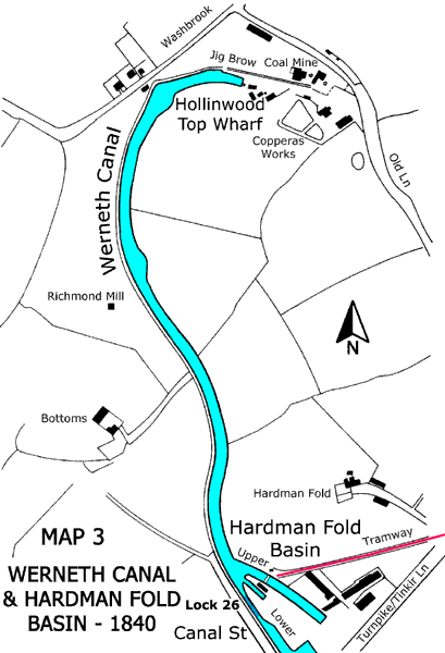
Jig Brow lies within an area of Oldham known as Werneth, which had rich coal deposits, and the Werneth Colliery Company owned a number of mines there. John and Joseph Lees, William Jones and John Evans established Werneth Colliery Company and reference to Chadderton Poor Law Rate Books shows that they held, 'Land, Wharf and Canal' at Hollinwood. These books illustrate the rise and fall of the Werneth Canal.
| Year | Gross Annual Value £ s d | Comments |
|---|---|---|
| 1847 | 18 0 0 | |
| 1858 | 24 0 0 | |
| 1862 | 24 0 0 | Including a Boat House |
| 1863 | 10 0 0 | |
| 1865 | 10 2 6 | |
| 1866 | 10 2 6 | |
| 1867 | 10 2 6 | Reduced on appeal to £1 0s 0d |
| 1867 | 1 2 6 | |
| 1868 | 1 2 6 | |
| 1869 | 1 2 6 | |
| 1871 | 1 2 6 | |
| 1873 | 1 2 6 |
The above table shows that the peak of prosperity for the Werneth Canal was reached in 1862. It then declined but held steady from 1863 until 1866, but in 1867 the annual value was reduced by just over 90% on appeal. The Werneth Canal then lingered on until 1871 but there was no entry for 1873. It can be deduced from this that commercial use of the Werneth Canal had virtually ceased by 1873, although the Distance Tables of September 1888 do make mention of its existence.
Further Reading
De Salis, Henry Rodolph, 1904. Bradshaw's Canals and Navigable Canals of England and Wales. Fleet Street, London: Henry Blacklock & Co Ltd.
Hadfield, George and Biddle, Gordon, 1970. The Canals of North West England. 2 Vols. Newton Abbot: David & Charles.
Fanning, Gerry, 2000. Hollinwood Canal. Radcliffe, Manchester: Neil Richardson.
